Arbury… sorry, Orchard Park

To the north of Cambridge a new housing estate is being built. Well, it was being built, though things seem to have slowed down a bit recently, presumably because the property market is in the doldrums.

I’ve seen some of the houses, and actually been inside one, and they’re not bad, as modern buildings go. But I have to wonder at the intelligence of the developers.

At first, they named the estate ‘Arbury Park’ – a delightful-sounding name unless you happen to ask a local, in which case you’d discover that Arbury, the estate next door, is, shall we say, not deemed to be amongst the more desirable areas of the city.

After building a large number of houses, I presume that they cottoned on to this because some months ago it was renamed ‘Orchard Park’, a ‘mixed use development including 700 prestige homes’. And they’ve managed to convey just some of this prestige in the proud sign that announces the project to passers-by.

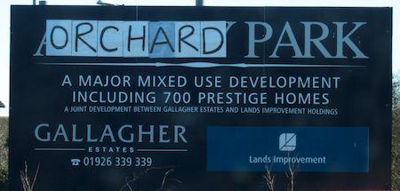
I assumed this was a temporary sign. Very many months ago.

I like the comment on the District Council web site – a wonderful example of dangerous punctuation:

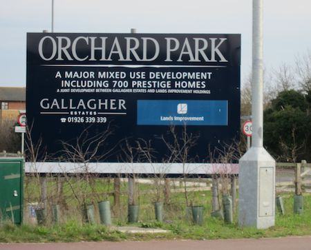
The site will provide 900 quality homes – 270 of which will be ‘affordable’.

Update: Have a look at the comments for some interesting background to the story… and in the afternoon of the day I posted this, I drove past the sign again, to find that it had finally, after many months, been replaced a couple of days before. Which makes it look much more professional, but now, knowing the story, I can’t help but feeling the old one was rather more fun!

Orchard Park update

Enjoyed this post? Why not sign up to receive Status-Q in your inbox?

5 Comments

As far as I can recall, there was a decision to rename the estate, but the developers and/or council didn’t bother replacing the signs. This was OK, as the residents luckily already had sign-making expertise, as no one had put streetname signs up and they had had to make their own. They therefore have beautiful, artistic street signs which were produced locally. And so eventually, the residents also stuck their own signs over the developers’s site signs, like the one you show here.

And Michael commented:

From working around Orchard Park, I think the temporary sign was done by the residents rather than the builders. Looks like the moment the recession hit lots of work just stopped, so there was (and in some places) ad-hoc signage put up by those living there. There was some very pretty street signs, clearly painted with a school like mentality, nicely bright and pretty – actually better than what the developers probably would have put in 🙂

Legally, the site was actually called Arbury Camps…it was the developers that “branded” it Arbury Park. The school was then named “Orchard Park”…to help minimise the confusion, the residents were polled on a name change and “Orchard Park” was the preferred result. The area officially became Orchard Park in April 2009 after it was legally separated from Impington and became a government parish in its own right.

The County Council were slow to replace the official road signs, but this has been chased through and is now done. Gallagher Estates commented that they saw no need to change the signs, but a guerilla campaign last autumn saw their signs re-labelled, and only a few days ago, Gallagher formally replaced the sign above with one for Orchard Park.

The new name reflects the history of the area which used to be part of the orchards for the Chivers jam business…Arbury Camps vaguely reflects the history that there used to be a Roman camp here called something like Hardburgh which over the centuries has mutated to Arbury. Calling the development Arbury Park and the school Orchard Park was just bizarre and would have led to huge confusion!!

The “DIY” street signs were created as part of the public arts project and were designed and installed by residents back in the first summer of occupation in 2007 when it became clear that we might have to wait several years for the different parties involved to install proper street signs…in the meantime, visitors, taxis, Tesco vans etc etc were getting lost every day. As best as possible, the DIY signs are being saved and will form part of an arts display on the site.

Hope that’s useful!.

Actually, the site was called Arbury Camp and contained the prehistoric earthwork (iron age) which gave the area its name. Take a look at old maps of the area and you will see it there ‘Arbury – site of camp’. There is conjecture about what the name might have been originally – Arbury or Harborough being two, but Arbury being by far the more prominent. Local people studied the area for the Arbury 1980 project, and this culminated in an exhibition in 1981 and a booklet called ‘Arbury is Where We Live!’ As for the name ‘mutating’ – all names have ‘mutated’ over time – including Cambridge and Chesterton. The amount of snobbery and silliness in the city – and the negating of local history – is hilarious. The local council arbitrarily alters wards – as it did shortly after the Arbury project, relegating North Arbury to King’s Hedges, despite the fact that large areas of the Manor Farm had contained fields called ‘Arbury’ and ‘Arbury Field’ and the Arbury Community Centre is now apparently in King’s Hedges. My family have lived in Cambridge for generations and I do find the snobbishness of the place amusing. Hyacinth Bucket would love it here – but not in Arbury or Orchard Park of course!

Thanks so much for your interest in Arbury. Historically, King’s Hedges lays NORTH of King’s Hedges Road, and Orchard Park was, of course, the Arbury Camp Farm. King’s Hedges Road was a short road leading only to the King’s Hedges Farm, north of the current road. I have started a blog on the Arbury area – unfettered by changeable ward designations (Arbury Ward has just regained Arbury Court from its stay in King’s Hedges Ward – which began in 2004 – absurd!). King’s Hedges Ward is historically meaningless – and is still very much part of the Arbury district, just as Stretten Avenue and Akeman Street are not. They were previously ‘Castle Ward’, but considered by locals as being ‘New Chesterton’. Meanwhile, Chesterton School teeters on the edge of Arbury Ward. It regained Bateson Road in 2004 from Arbury Ward, but Bateson Road is the only West Chesterton Ward in that neighbourhood! Defining areas by wards – which used to be simply an electoral thing – is silly, but has gained prominence in the digital era. If you look at online maps, this is how the areas are defined – and they change after re-wardings! This is not encouraging any sense of history or community – and is now affecting paper maps. You may be interested in the 1981 book – ‘Arbury Is Where We Live!’ – shortly to be uploaded to the blog and the article I link you to now – detailing the historic location of King’s Hedges and some parish designations in 1918. Please feel free to leave comments. Here is the link to the article I think may interest you: https://arburycambridge.blogspot.com/2021/11/arbury-1918-death-of-soldier-confusion.html

Got Something To Say:

Your email address will not be published. Required fields are marked *

To create code blocks or other preformatted text, indent by four spaces:

    This will be displayed in a monospaced font. The first four 
    spaces will be stripped off, but all other whitespace
    will be preserved.
    
    Markdown is turned off in code blocks:
     [This is not a link](http://example.com)

To create not a block, but an inline code span, use backticks:

Here is some inline `code`.

For more help see http://daringfireball.net/projects/markdown/syntax

*

© Copyright Quentin Stafford-Fraser