Tag Archives: maps

Train-ing data

I very seldom use the railways in the UK any more, though I did make two short one-way train journeys in 2023. The first was to collect our campervan from the dealer, and the second was when Rose, Tilly and I took our inflatable kayak from the little station at Bures one stop up the line to Sudbury, and then paddled back down the River Stour to where we’d left the car in the station car park.  That was fun.  They do have their uses for one-way journeys.

But I don’t think I went on a train at all in 2024. (Oh, actually, wait a sec… none in the UK: there were a couple of trips on the Athens metro.)   I do quite like trains as a theoretical concept, and use them when I’m in other parts of the world, but the reality here in the UK is that, unless you’re unfortunate enough to live in London, driving is generally much more comfortable, more reliable, usually quicker, and always much cheaper than going by rail, so there are very few circumstances when I’d choose to go by train.  Even the obvious advantage that you can read on the train is now significantly diminished by having Audible in my car.

And before anyone points out the green credentials of rail travel, it’s less clear-cut than you might think. This page suggests that even if you include all the CO2 used in manufacture, the carbon footprint of two people travelling in an EV will work out at 90g/person/mile; very similar to the 80g/person/mile of a standard-class UK train seat, and way better than a first-class seat.  If there are more than two of you in the car, you can feel especially virtuous, as well as saving lots of money. This UK government report suggests that EVs and trains have broadly the same emissions if there are only 1.6 people in the car.

There was a brief period in the past when I worked in London for a few weeks, but I quickly realised that life is not a rehearsal, you only go around once, and spending any significant part of one’s all-too-limited time on a commuter train was sheer madness!  But I’ve found that as long I only use the railways for unusual trips at off-peak periods, or on holidays, I can maintain a nostalgic fondness for them.  (And if you’re ever able to take all that money you save over the years by not going on trains and blow it all on one ticket on the Orient Express to Venice, I can definitely recommend the experience!)

All of which is a rather long introduction to the fact that I do still find this live train map from SignalBox to be rather pleasing!  You can sit comfortably at home, picture all those trains rushing in around the country, and feel some sympathy (or perhaps schadenfreude!) for those whose icons are not green.

Google Tip of the Day

Here’s a quick two-and-a-half minute video which might save you some time one day, if not now!

Measuring distances and areas in Google satellite view

(A direct link is here, in case you can’t see the embedded video.)

What 3 words?

This is a brilliant idea. Take the world and divide it into 3m squares. Then, given a modest vocabulary, you can label each square using just three words.
For example, I work half-time at ‘faced.ears.sport’, which you can find by typing it into the What3Words map at map.what3words.com, or you can turn it into a handy URL:

http://w3w.co/faced.ears.sport

Isn’t that much easier than saying ‘The south west corner of the William Gates building at 15 J J Thomson Avenue, Cambridge, CB3 9JW, UK’? Or ‘52.210577 N 0.092133 E’?

It’s even more valuable, though, in countries where addressing schemes are less well established or non-existent.

Now, it has a couple of limitations that I can see. First, you do need to be fairly precise about those words if, say, you’re reading them over the phone. If, instead of ‘faced.ears.sport’, you went to ‘face.ears.sport’, you’d find yourself in a little residential street in Montana, which would be delightful, but you wouldn’t find me there on a typical work day. ‘faced.ears.port’ is in Louisville, Kentucky. However, the fact that they’re so spread out probably makes such errors less likely to go undetected – this is deliberate.

The second limitation is that this is a commercial operation and not an open standard, which is a pity in some ways, but understandable. It’s free for individuals to use – there’s a free iOS and Android app, for example – and the pricing page contains this assertion:

If we, what3words ltd, are ever unable to maintain the what3words technology or make arrangements for it to be maintained by a third-party (with that third-party being willing to make this same commitment), then we will release our source code into the public domain. We will do this in such a way and with suitable licences and documentation to ensure that any and all users of what3words, whether they are individuals, businesses, charitable organisations, aid agencies, governments or anyone else can continue to rely on the what3words system.

I think it’s a brilliantly simple idea. The concept has been used in other situations (passwords, PIN numbers etc), but works really well here.

Time travel

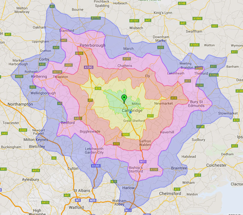
My friend Mike Flynn has been working for some years on very fast routing algorithms — routing as in maps, that is — and his primary demonstration of this is TimeToAnywhere – a system which can work out how long it takes to drive from one location to everywhere else on the map.

So you can say, for example, “There’s been an accident here. Which ambulances could reach it in less than 15 mins?” Or, “I work in Dry Drayton. Where could I live, and still have less than a half-hour commute?”

timetoanywhere

Each coloured boundary represents 10 minutes’ driving.

This is pretty, but those of you with a computing background may also realise that, using most of the standard algorithms, this is also a very time-consuming problem when you try do it across this number of points. Mike, however, measures the time taken by his system in microseconds.

He’s recently set up a demo server which, if it doesn’t get too swamped, is fun to play with to get a feel for the speed! You can find it at TimeToAnywhere.com, and if you want to know how to get the most out of it, watch Mike’s short video.

It’s raining again…

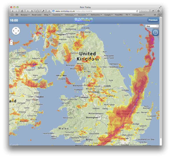
…and so I turn to one of the most useful sites for British dog-walkers (cyclists, etc), which can help you answer the questions, “Is it about to rain?” and “How long will this rain last?” At the moment, the former question is largely rhetorical, but the answer to the latter can be very useful.

It was Richard who first pointed me at raintoday.co.uk, which gives you a rough animation of the radar precipitation map over the last couple of hours, so you can get a feeling for how fast the clouds are moving.

Screen Shot 2014-01-25 at 16.15.47

Very very handy. And very British.

It’s also worth knowing that if you put ‘/mobile’ on the end of the URL, you lose some features, but you also don’t get any ads. I have it bookmarked on one of the home screens of my iPhone.

© Copyright Quentin Stafford-Fraser