Google Tip of the Day
Here's a quick two-and-a-half minute video which might save you some time one day, if not now!
Measuring distances and areas in Google satellite view
(A direct link is here, in case you can't see the embedded video.)
Quentin Stafford-Fraser's blog
One should always have something sensational to read on the net...
Here's a quick two-and-a-half minute video which might save you some time one day, if not now!
Measuring distances and areas in Google satellite view
(A direct link is here, in case you can't see the embedded video.)
I'm a big fan of my Apple AirTags. I have a few of them now, and they've been jolly useful on several occasions, enabling me to find things quickly that would otherwise have involved more time and stress, or to notice that something has been left behind and so recover it far sooner than would otherwise have been possible.
They're very cunning devices. Tilly even has one on her collar now!
For those not familiar with the underlying technology, the general challenge with locating devices in the past has been that it typically involves two components: a GPS receiver (to find out where the item is), and a connection to the mobile phone network (to report that location to whomever may be looking for it). Both of these need significant battery power, so trackers have been bulky, required frequent recharging, and the phone connection generally implied a subscription. In the past, therefore, tracking has generally been reserved for valuable things which can carry big batteries, like cars, or like smartphones which happen already to have the necessary functions built-in and get recharged every night.
Since I have been known, just occasionally, to be a little absent-minded, I have made extensive use of Apple's 'Find my...' system over the years to locate iPhones, iPads, even spouses. And before you scoff, I should mention that my knowledge of how to use it also once won me an enthusiastic embrace in the middle of a field from a rather beautiful young woman who was a complete stranger to me. So there! But that's a story for another day...
Anyway, the AirTags have neither a GPS nor a big battery, and yet still manage to transmit their location back to you remarkably effectively in most circumstances. How do they do it? Well, they can be detected by any passing iPhone, and there are a billion of those moving around the world, so there's a surprisingly good chance that if a human passes close to your lost bunch of keys, you'll get to know about its location fairly soon.
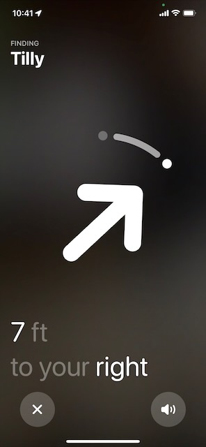 The AirTags are also, I believe, the first large-scale deployment of UWB location technology, the details of which are beyond the scope of this post, but it basically means that if you have a recent iPhone, when you get really close to the Tag, you can be guided to it using a compass-needle-type display, in a way that would not be possible with something like Bluetooth alone. You can find out not just that your wallet is in this room, but that it's behind this sofa cushion.
Still, my use of AirTags has been very practical and prosaic. Others have had more fun, and a YouTuber calling himself AirtagAlex has done some wonderful experiments over the last few months of mailing AirTags to different parts of the world and seeing the routes they took to reach their destination.
I rather liked his latest video, though, which explores one of those questions you might never have thought of asking in the past: what actually happens if you get on a plane and leave something in the pocket of the seat in front of you?
Previously on Status-Q...
Regular readers may remember that a couple of months ago, I lost my glasses and found them again. If you missed that particularly gripping episode, turn back to Location, location, location (or, 'How technology saved me a few hundred quid yesterday') and then you'll understand the background here.
After posting it, my friend Phil Endecott got in touch with me. "Am I to understand", he said, "that you would find it useful if you had a map app that could show both the locations of your photos and your current location at the same time? If so, I may have just what you need...."
And he did indeed. Phil, you see, is the author of UK Map, an iOS app that I've had for as long as I can remember, and one I should talk about more, because I use it all the time, especially when looking for new dog-walking routes. Yes, I may use Google Maps to find out how long it'll take me to drive there, and Streetview to check that there's likely to be a parking spot when I get there, but once I've laced up my walking boots, then I generally switch to UK Map. It combines free or paid-for Ordnance Survey maps with footpaths from Open Street Map, and, certainly round here, it's a much better guide than almost anything else as to where you can actually go for a walk.
New features get added periodically and, like much of the cool stuff, are often buried deep in some menu below some unassuming icon in the corner, making them very easy to miss, so you really do want to go to the home page and read it carefully to see what the app can do, and then to the help button in the app to see how to do it. I don't check these often enough, but when Phil's message prompted me, I had another explore and found that, yes, it can show your photos on your maps. This is the site of my aforementioned adventure:
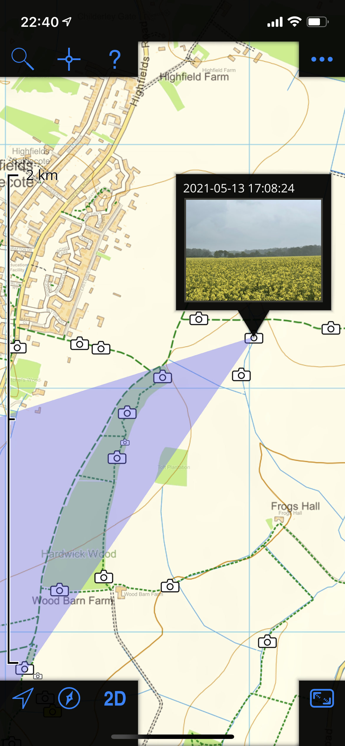
and if I had been there at the time of writing this, the little blue dot would indeed have shown me exactly what I needed to know. (The violet-coloured triangle there, by the way, is showing the rough direction in which the phone was pointing when it took the picture, and therefore shows what you may be able to see in it. Neat, eh?)
Anyway, I've mentioned UK Map before, but I've used it for so many years that I take it for granted. I do think that if you put in a little time learning what it can do, you'll find it repays its very modest purchase price. Actually, it'll repay that even if, like me, you really only scratch the surface.
P.S. If you happen to be anywhere other than the UK, this will be of limited use, but if you're in North America, Phil is also the author of the highly-rated Topo Maps
 This is a brilliant idea. Take the world and divide it into 3m squares. Then, given a modest vocabulary, you can label each square using just three words.
For example, I work half-time at 'faced.ears.sport', which you can find by typing it into the What3Words map at map.what3words.com, or you can turn it into a handy URL:
http://w3w.co/faced.ears.sport
Isn't that much easier than saying 'The south west corner of the William Gates building at 15 J J Thomson Avenue, Cambridge, CB3 9JW, UK'? Or '52.210577 N 0.092133 E'?
It's even more valuable, though, in countries where addressing schemes are less well established or non-existent.
Now, it has a couple of limitations that I can see. First, you do need to be fairly precise about those words if, say, you're reading them over the phone. If, instead of 'faced.ears.sport', you went to 'face.ears.sport', you'd find yourself in a little residential street in Montana, which would be delightful, but you wouldn't find me there on a typical work day. 'faced.ears.port' is in Louisville, Kentucky. However, the fact that they're so spread out probably makes such errors less likely to go undetected - this is deliberate.
The second limitation is that this is a commercial operation and not an open standard, which is a pity in some ways, but understandable. It's free for individuals to use - there's a free iOS and Android app, for example - and the pricing page contains this assertion:
If we, what3words ltd, are ever unable to maintain the what3words technology or make arrangements for it to be maintained by a third-party (with that third-party being willing to make this same commitment), then we will release our source code into the public domain. We will do this in such a way and with suitable licences and documentation to ensure that any and all users of what3words, whether they are individuals, businesses, charitable organisations, aid agencies, governments or anyone else can continue to rely on the what3words system.
I think it's a brilliantly simple idea. The concept has been used in other situations (passwords, PIN numbers etc), but works really well here.
My friend Mike Flynn has been working for some years on very fast routing algorithms -- routing as in maps, that is -- and his primary demonstration of this is TimeToAnywhere - a system which can work out how long it takes to drive from one location to everywhere else on the map.
So you can say, for example, "There's been an accident here. Which ambulances could reach it in less than 15 mins?" Or, "I work in Dry Drayton. Where could I live, and still have less than a half-hour commute?"
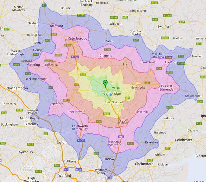
Each coloured boundary represents 10 minutes' driving.
This is pretty, but those of you with a computing background may also realise that, using most of the standard algorithms, this is also a very time-consuming problem when you try do it across this number of points. Mike, however, measures the time taken by his system in microseconds.
He's recently set up a demo server which, if it doesn't get too swamped, is fun to play with to get a feel for the speed! You can find it at TimeToAnywhere.com, and if you want to know how to get the most out of it, watch Mike's short video.
 You know those coverage maps that mobile service providers create? The ones that tell you that, yes, there's blanket 3G coverage in your favourite holiday destination, but when you get there you discover mean 'slight 3G coverage for people sitting on top of their chimneys facing west under optimal stratospheric conditions'?
Well... it strikes me that, now phones have accessible GPS data, we shouldn't need to rely on these particular bits of marketing propaganda. Somebody could write a phone app which periodically captures details of the signal and the phone's location, and uploads them to a service which creates a map showing the true picture. Imagine you could look at your movements over a month or two and discover which operator would really provide you personally with the best service. If you were running the application, the system could even tell you that automatically! (Which would be a good way to get the data-gathering mechanism widely adopted).
Has anyone done this? I might write it up as a student project proposal...